Hello all,Rather than Googling the formula, my first thought was to go back to
I have a world map using the Mercator projection, and would like to plot some stuff on it using Latitude and Longitude.
The problem is that I can't seem to get the formule I found to spit out the correct value for Y.
-- The map :
https://upload.wikimedia.org/wikipedia/commons/thumb/7/73/Mercator_projection_Square.JPG/250px-Mercator_projection_Square.JPG
-- The formula :
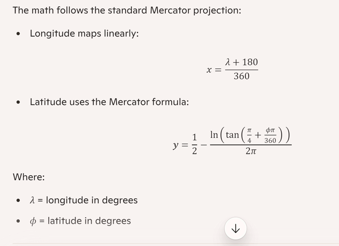
Y = ln( tan(latitude) + sec(latitude) )
where "ln(...)" is log(...) / log(10)
... at least, that is what I could google about it.
If it _is_ light-source-at-centre, then the Y co-ordinate would just be
the tangent of the latitude
J.P. ,
First off, FYI, Paul has minimized his posting about the subject to the Win10 group only. If you're not there already it might be a good idea to take a peek.
If it _is_ light-source-at-centre, then the Y co-ordinate would just be
the tangent of the latitude
Somewhere along the road I had a similar thought. But why than do all the formules I now have (four at the moment) all do a tan() and than wrap that up in a log() ? There must be something to it.
[John by the way :-) ]
I replied to the posting I did, thinking I was the only respondent -
probably in the W7 'group; I saw the other responses when I moved
to one of the other 'groups, but too late then to amend my post.
...If it _is_ light-source-at-centre, then the Y co-ordinate would just be
the tangent of the latitude
But why than do all the formules I now have (four at the moment)
all do a tan() and than wrap that up in a log() ? There must be
something to it.
Indeed! But I can't think what.
Did you _try_ using just the tangent on a couple of places? Or perhaps
just a couple of latitudes, to see if the lines come out where they are
on the plot?
You'd probably have to do that in the first place anyway,
to see what the vertical scale _is_; if doing that for say the ten and
forty degree lines (assuming that's what the ones on the plot are) gives different scales, then you'd know it isn't just that.
On 2026/1/14 8:24:17, R.Wieser wrote:
Hello all,
I have a world map using the Mercator projection, and would like to plot
some stuff on it using Latitude and Longitude.
The problem is that I can't seem to get the formule I found to spit out the >> correct value for Y.
-- The map :
https://upload.wikimedia.org/wikipedia/commons/thumb/7/73/Mercator_projection_Square.JPG/250px-Mercator_projection_Square.JPG
-- The formula :
Y = ln( tan(latitude) + sec(latitude) )
where "ln(...)" is log(...) / log(10)
... at least, that is what I could google about it.
Rather than Googling the formula, my first thought was to go back to
first principles: as the name implies, a map projection can be thought
of as being created by shining a light through the earth (globe) onto a
sheet of paper - either flat and fixed to the globe at one point, or -
more commonly - a cylinder wrapped round the globe, touching at one
circle (often the equator), and then unrolled. Once this is realised,
basic geometry should make calculation of the co-ordinates fairly simple.
Unfortunately, to do this, one needs to know where the nominal light
source is. And - despite it being a _long_ article - I can't find a
statement of this in the Wikipedia article about the Mercator projection
- other that that - I _think_ - it _isn't_ the centre of the earth
(so-called "radial"), though is often thought to be (certainly Google's
AI thinks it is).
If anyone _can_ find out where the light source point is for the
Mercator projection, I'd love to know! (And it would answer Rudy's
question.)
(One other position for the light source I remember from last time I
looked into this - which was probably over 40 years ago! - is on the
opposite surface of the globe to the projection point (i. e. sort of
tracking round opposite the map "printing"); I don't think it's that,
though, as that would show the poles, though still distorted.
If it _is_ light-source-at-centre, then the Y co-ordinate would just be
the tangent of the latitude (scaled appropriately for the map size).
Even if it isn't, this _may_ be close enough - try a few places.
Your coordinates for NYC, where did you get those coords ???You used a website to work out 40 + 42/60 + 46/3600? :-)
There is an article in Wikipedia I used, complete with a tiny
map widget when you click an icon near the coord info.
40 42 46 -74 0 22 New York City value (Wikipedia)
40.71277778 -74.00611111 DMS to D via https://www.latlong.net/degrees-minutes-seconds-to-decimal-degrees
I think the equation is pretty close. But I'm not happy thatYes, this has been a puzzle, for what seems like a simple question!
there is an error still there.
Paul
On 2026/1/16 10:8:22, Paul wrote:
[]
Your coordinates for NYC, where did you get those coords ???
There is an article in Wikipedia I used, complete with a tiny
map widget when you click an icon near the coord info.
40 42 46 -74 0 22 New York City value (Wikipedia)
40.71277778 -74.00611111 DMS to D via https://www.latlong.net/degrees-minutes-seconds-to-decimal-degrees
You used a website to work out 40 + 42/60 + 46/3600? :-)
[]
...Did you _try_ using just the tangent on a couple of places?
I have to do some more experiments.
Your coordinates for NYC, where did you get those coords ???
40 42 46 -74 0 22 New York City value (Wikipedia)
40.71277778 -74.00611111 DMS to D via https://www.latlong.net/degrees-minutes-seconds-to-decimal-degrees
X=0.294427 Y=0.375981 merc.exe (the CoPilot program)
John,
...Did you _try_ using just the tangent on a couple of places?
I have to do some more experiments.
After having done so, it looks like that
tan(DegToRad(Latitude)*0.78)\2.53627
gives a nice result.
By the way, 0.78 is rather close to Pi/4 . Somehow that raises my suspicion that that is the actual value to be used, and my 0.78 is caused by my "that looks good" eyeballing ...
Regards,
Rudy Wieser
Paul
Your coordinates for NYC, where did you get those coords ???
If you mean 39, -77 its probably from me.
Looking back in my docs I see I have an image of a globus wit the lat/long lines on it, mentioning 39, -77. The only problem is that it mentions Washington DC, and not New York. I've got no idea how I mixed those two up. My apologies.
40 42 46 -74 0 22 New York City value (Wikipedia)
40.71277778 -74.00611111 DMS to D via
https://www.latlong.net/degrees-minutes-seconds-to-decimal-degrees
X=0.294427 Y=0.375981 merc.exe (the CoPilot program)
Is there any chance you can (re)post the used formule (just to be sure I'm using the correct one) and some intermediate results (especially the ones
fed into the tan() an log() functions) so I can verify what the formule is doing here (and spot my mistake(s)) ?
Regards,
Rudy Wieser
Asssuming DegToRad() just means multiply by pi / 180 ...
... then the above simplifies to tan(Latitude*pi*pi/720)\2.53627, and
of course pi*pi/720 can be given as a constant.
As I cannot get any formule to work I'm going to try this one last time.
Below are two formules for converting a lattitude on a Mercator-projection map into a -1 ... +1 result that needs to be multiplied by half the maps-images height and subtracted from the equator (the map-images top-left is 0,0).
I've split the calculations up into multiple parts, hoping that someone can tell me where one, or perhaps both, go awry.
-- Formule: ln( tan(latitude) + sec(latitude) )
Lat: 39
DegToRad(39) -> 0.680952
tan(0.680952) -> 0.810238
sec(0.680952) -> 1/cos(0.680952) -> 1.287045
ln(0.810238+1.287045) -> log(0.810238+1.287045)/log(10) -> 0.321657
0.321657 is *way* too high.
-- Formule: log( tan(PI/4.0 + rad/2.0) ) / (2.0 * PI)
Lat: 39
DegToRad(39) -> 0.680952
tan(PI/4+0.680952/2) -> 2.098991
log(2.098991) -> 0.741457
0.741457/(2*PI) -> 0.117959
0.117959 is *way* to low
ln(2.097283) = 0.740643 # Via the ln() button on my calculator
The plot origin must not be where we think it is.
Notice how in a lot of these mathematics discussions, nobody labels a damn thing.
0.117959 is *way* to low
But it is 0.5 minus that number, so 0.382 .
Paul,
ln(2.097283) = 0.740643 # Via the ln() button on my calculator
And that 0.740643 points to somewhere between the northpole and canada on an ice plate. Where I'm quite sure Washington DC isn't located.
Which was why I started to doubt that "ln()" equals "log()". But if not, what is it ?
The plot origin must not be where we think it is.
Well, thats easy to check : Just calculate the result for a Latitude of Zero degrees. It should point at the equator.
Notice how in a lot of these mathematics discussions, nobody labels a damn >> thing.
Just mathematics ? A couple of weeks ago I tried to find example code for OpenSLL. I could find some, but with zero indication which version of the DLL it was for - and it matters a *lot*. It frustrates me to no end.
0.117959 is *way* to low
But it is 0.5 minus that number, so 0.382 .
In my previous message I mentioned that I multiply the result by half the height of the map, and subtract it from the equator (again, half the height of the map). That is the same, right ?
Actually, it isn't. :-)
Now you have shown that the log() in the formule you presented is exactly that (and not a elog() (natural log?) ) I had some solid ground from which I could look further.
The whole problem is that your formule multiplies by the full height of the map, and my "simplified" one multiplied by *half* the maps height (and than subtracts from the equator).
When I multiplied my result by two the result was the same as what came
outof your formule.
Thank you for that. :-)
mea culpa : after noticing that my implementation of the formule didn't work I *should* have first tried to implement it as provided. :-|
Than only one thing remains : Any idea why the first formule doesn't give
the expected result ?<whistle>
Regards,
Rudy Wieser
I would expect most people would think that log(A) means log to base 10 of
A while ln(B) is natural log of B if they were just shown without any explanation.
EllisMorgan,
I would expect most people would think that log(A) means log to base 10 of >> A while ln(B) is natural log of B if they were just shown without any
explanation.
As I mentioned, I googled for what "ln()" could mean. I got information back that different professions use "log()" to mean whatever they want it to mean. :-(
I did however find how to use "log()" to emulate "ln()" (as I showed in my first message). Alas, the result was still not near the expected one.
If you can point out what mistake(s) I made with that (first) fomule or my conversion of it I would be much obliged.
Regards,
Rudy Wieser
If you take a math course, you're taught it is as Ellis explains.
As I cannot get any formule to work I'm going to try this one last time.
Paul,
If you take a math course, you're taught it is as Ellis explains.
Good for Ellis I suppose. How does that help me, having googled and found that different professions use those different names as they bloody wel please ?
Also, in my very first posy I included "where ln(...) is log(...) / log(10)", indicating that I already had the idea that "ln()" *PROBABLY* was the natural logarithm, and how to get it using the standard base-10 log().
I ALREADY TRIED THAT, and still didn't get the expected result.
A few posts back I've provided the origional formule, the replacements I had to make ( "ln()" and "sec()" ) and gave several intermediate results.
*Please* put that formule into whatever you want to use and see where the intermediate results differ from mine - so I know were the problem is and can try to fix it.
Regards,
Rudy Wieser
There are three stages to this...
1. The mathematical conversion from latitude (and longitude) to the
position on the plane map *relative to its centre*
2. The _scaling_ required, depending on the size of the map image.
Which again will depend on the size of the image (and may be different
for X and Y).
I think _most_ of those contributing to this discussion know that,
but have not been making it very clear which bits of their formula(e)
do what.
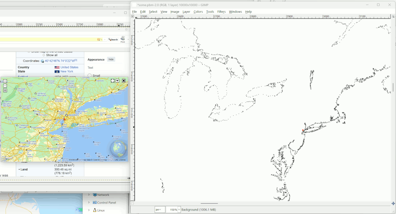
I wrote a program, worked an example and put a dot on a map
in a posted picture. That's enough.
John,
There are three stages to this...
1. The mathematical conversion from latitude (and longitude) to the
position on the plane map *relative to its centre*
Nope. There is no rule that that center must be taken as the origin. Take the formule Paul provided for instance. It returns a result in the range of 0 to 1 .
2. The _scaling_ required, depending on the size of the map image.
Which again will depend on the size of the image (and may be different
for X and Y).
Worse : Mercator maps go from +85 to -85 latitude. That must be part of the
formule (I've found several maps where the south-pole is cut off, and a bit of the north too. iow, useless without further information).
But again no. The result of the formule *is* the scaling (in your and my usage ranging from +1 to -1, in Pauls formule case, from 0 to +1). You just apply it on whatever size Mercator-style map you have handy.
I think _most_ of those contributing to this discussion know that,
but have not been making it very clear which bits of their formula(e)
do what.
I do not need to know what all the parts of a car do, as long as I can drive it. The same goes for these two formules. Latitude goes in, something I can apply comes out.
Though the whole problem isn't that nobody understood what you said there, but that nobody was willing to compare the (intermediate) results I posted with what they got themselves, allowing me to locate where I made my mistake(s?).
Not when I asked for it in my first post, and not when I rather explicitily asked for it a few days back. :-(
Regards,
Rudy Wieser
On 2026/1/24 8:28:44, R.Wieser wrote:
John,
There are three stages to this...
1. The mathematical conversion from latitude (and longitude) to the
position on the plane map *relative to its centre*
Nope. There is no rule that that center must be taken as the origin. Take
the formule Paul provided for instance. It returns a result in the range of
0 to 1 .
It makes it easier to understand what's going on if done in these three stages. And assuming we're talking of the Web Mercator image as shown at https://upload.wikimedia.org/wikipedia/commons/e/ec/Web_maps_Mercator_projection_SW.jpg,
0 degrees latitude and longitude _is_ at its centre.
2. The _scaling_ required, depending on the size of the map image.
Which again will depend on the size of the image (and may be different
for X and Y).
Worse : Mercator maps go from +85 to -85 latitude. That must be part of the
(Or 85.051129.)
formule (I've found several maps where the south-pole is cut off, and a bit >> of the north too. iow, useless without further information).
No, just because the map is cut off at those latitudes, that figure does
NOT have to appear in the formula. The poles _have_ to be cut off,
otherwise the map would be infinitely tall, and very distorted at the poles.
But again no. The result of the formule *is* the scaling (in your and my >> usage ranging from +1 to -1, in Pauls formule case, from 0 to +1). You just
apply it on whatever size Mercator-style map you have handy.
The above image, according to my browser, is 2068 by 2060 pixels.
True, if that really is all you want. As a scientist/engineer/just
I think _most_ of those contributing to this discussion know that,
but have not been making it very clear which bits of their formula(e)
do what.
I do not need to know what all the parts of a car do, as long as I can drive
it. The same goes for these two formules. Latitude goes in, something I >> can apply comes out.
enquiring mind, I don't like to blindly use a formula without knowing
what it does - or perhaps _why_.
Yes, you can drive a car without knowing what each bit does. But knowing
at least some of them will improve your longevity (wear and tear on the mechanisms), fuel economy, performance ... as you drive.
Though the whole problem isn't that nobody understood what you said there, >> but that nobody was willing to compare the (intermediate) results I posted >> with what they got themselves, allowing me to locate where I made my
mistake(s?).
That is indeed one of many problems.
It would be good to see where the following points come out on e. g. the above image, using any formula (longitude given first):
0, 0
+/- 180, 85
+/-180, -85
and some known place, such as London or New York.
I guess if you just want a formula that works, and _aren't_ bothered
Not when I asked for it in my first post, and not when I rather explicitily >> asked for it a few days back. :-(
Regards,
Rudy Wieser
about the three steps - the mathematical conversion from angle to linear dimension, the scaling, and the offset - then we're very different
minds. Which is of course fine; if we were all the same, it'd be a
boring world.
It makes it easier to understand what's going on if done in these
three stages.
And assuming we're talking of the Web Mercator image as shown at https://upload.wikimedia.org/wikipedia/commons/e/ec/Web_maps_Mercator_projection_SW.jpg,
0 degrees latitude and longitude _is_ at its centre.
No, just because the map is cut off at those latitudes, that figure
does NOT have to appear in the formula. The poles _have_ to be
cut off, otherwise the map would be infinitely tall, and very distorted
at the poles.
I do not need to know what all the parts of a car do, as long as I canTrue, if that really is all you want. As a scientist/engineer/just
drive
it. The same goes for these two formules. Latitude goes in, something
I
can apply comes out.
enquiring mind, I don't like to blindly use a formula without knowing
what it does - or perhaps _why_.
It would be good to see where the following points come out on e. g. the above image, using any formula (longitude given first):
0, 0
+/- 180, 85
+/-180, -85
and some known place, such as London or New York.
Paul,
I wrote a program, worked an example and put a dot on a map
in a posted picture. That's enough.
I already knew that both of those formules where expected to work, so you wasted your time in proving that your CoPilot provided one does.
*What I was asking for* was a bit of help to why my implementation of first one, than both formules refused to return a usable result. I gave you *everything* to be able to do so.
You think that what you did was enough ? How ? You did not even *try* to answer my question. :-(
Regards,
Rudy Wieser
Show me current code.
Have the program print out something like this.[snip list of values]
Paul,
Show me current code.
Explain to me how my code would help you any better than the worked-out formule with its input, partial and full results I already gave.
Besides, the language I'm using might not be the one you know/are comfortable with, thereby adding yet another layer to the problem.
English?
One of them is a formula; two or more, though pronounced
form-you-lee, are formulae
John,
English?
One of them is a formula; two or more, though pronounced
form-you-lee, are formulae
Are you sure about that ?
https://www.merriam-webster.com/dictionary/formule
Regards,
Rudy Wieser
Ah, UK/US difference again. In UK, the form formule is 1677-1829 (https://www.oed.com/search/dictionary/?scope=Entries&q=formule),
whereas the form formula is current
formule comes from the French formule,
Isn't language fun!
John,
English?
One of them is a formula; two or more, though pronounced
form-you-lee, are formulae
Are you sure about that ?
https://www.merriam-webster.com/dictionary/formule
Regards,
Rudy Wieser
John,
Ah, UK/US difference again. In UK, the form formule is 1677-1829
(https://www.oed.com/search/dictionary/?scope=Entries&q=formule),
whereas the form formula is current
merriam-webster doesn't make any such distinction. Who am I going to believe ?
--formule comes from the French formule,
Yes, thats what the link I posted says. And for funzels it mentions your singular "formula" as being the plural of of "formule".
Isn't language fun!
Almost as funny as math. :-(
Regards,
Rudy Wieser
On 26/01/2026 2:01 am, R.Wieser wrote:
John,
Ah, UK/US difference again. In UK, the form formule is 1677-1829
(https://www.oed.com/search/dictionary/?scope=Entries&q=formule),
whereas the form formula is current
merriam-webster doesn't make any such distinction. Who am I going to believe >> ?
merriam-webster is Yank, isn't it??
Nuff said.
formule comes from the French formule,
Yes, thats what the link I posted says. And for funzels it mentions your >> singular "formula" as being the plural of of "formule".
Isn't language fun!
Almost as funny as math. :-(
Regards,
Rudy Wieser
On 25/01/2026 10:02 pm, R.Wieser wrote:
John,Dictionarys .... What would THEY know??
English?
One of them is a formula; two or more, though pronounced
form-you-lee, are formulae
Are you sure about that ?
https://www.merriam-webster.com/dictionary/formule
Regards,
Rudy Wieser
On 2026/1/26 11:11:11, Daniel70 wrote:
On 25/01/2026 10:02 pm, R.Wieser wrote:
John,Dictionarys .... What would THEY know??
English?
One of them is a formula; two or more, though pronounced
form-you-lee, are formulae
Are you sure about that ?
https://www.merriam-webster.com/dictionary/formule
Regards,
Rudy Wieser
More than you could possibly imagine [(C) Marvin]
On 2026/1/26 11:13:59, Daniel70 wrote:
On 26/01/2026 2:01 am, R.Wieser wrote:
Isn't language fun!
Almost as funny as math. :-(
Well, I enjoy it. (Can't really help it in my family - both parents were language teachers and brother works for the dictionary.) And I do enjoy _some_ maths (UK spelling!) too.
On 26/01/2026 11:44 pm, J. P. Gilliver wrote:
On 2026/1/26 11:11:11, Daniel70 wrote:Hmm!! "Marvin" .... is that Marvin as in THHGTTG??
On 25/01/2026 10:02 pm, R.Wieser wrote:
John,Dictionarys .... What would THEY know??
English?
One of them is a formula; two or more, though pronounced
form-you-lee, are formulae
Are you sure about that ?
https://www.merriam-webster.com/dictionary/formule
Regards,
Rudy Wieser
More than you could possibly imagine [(C) Marvin]
As much as it grates on me, I can, sort of, accept the Yank 'Math' ... I >mean the full word IS 'MathematicS' and, if you were going to truncate
it by dropping the tail-end, then ALSO dropping the 's' makes sense
..... but it sounds so awkward!!
On Tue, 27 Jan 2026 19:59:05 +1100, Daniel70
<daniel47@nomail.afraid.org> wrote:
As much as it grates on me, I can, sort of, accept the Yank 'Math' ... I
mean the full word IS 'MathematicS' and, if you were going to truncate
it by dropping the tail-end, then ALSO dropping the 's' makes sense
..... but it sounds so awkward!!
You want awkward? Try telling everyone "I won a maths debate! I won a
maths debate!" See if they look at you funny.
| Sysop: | Amessyroom |
|---|---|
| Location: | Fayetteville, NC |
| Users: | 70 |
| Nodes: | 6 (0 / 6) |
| Uptime: | 39:18:34 |
| Calls: | 948 |
| Calls today: | 2 |
| Files: | 1,325 |
| Messages: | 280,644 |